Cartagena, Columbia

December 16th, 2016

Friday, December 16, 2016 – Partly cloudy, light breeze, 88 degrees

According to the ship’s log this morning, “the Pilot guided us through the narrow Bocachia Channel and through the Bay of Cartagena towards the inner harbour.  The Captain maneuvered the ship in to our assigned berth. By 0929 the ship was All Fast fore and aft.”  It would be so much fun to be up in the bridge and watch all this going on instead of reading a report!

dsc_9952

We had signed up for an “self-guided tour” of the Old Town which was just transportation from the ship to the historic district.  We passed through Las Murallas, the wall, and under the Monumento Torre del Reloj, Clock Tower.  

dsc_9983

I’ll never understand why we had only a half day in Cartagena, Columbia whose historic districts of El Centro and San Diego, are UNESCO World Heritage Sites.  Cartagena is a big fascinating modern city of almost a million people with a lot to explore, including the Spanish colonial walled district, 16th century fortress and churches, and scores of other historical sights.  

dsc_9978

dsc_9994

The local guide pointed out historic buildings and told us the weather in Cartagena is always “hot or hotter.” I wasn’t sure which we had today, but with 90 degree temperatures, direct mid-day sun, and 85% humidity, it was HOT!

dsc_0055

Spanish colonial architecture is attractive with shaded wooden balconies hung over narrow sidewalks.  Many of the stucco buildings were brightly painted and some had shady arcades which extended to the street. 

dsc_0075

We became “shade seekers” choosing shady narrow streets filled with vendors and locals.  We had been warned about aggressive vendors who followed us around, but they were harmless, just trying to earn a living.

dsc_0008

dsc_0012

dsc_0146

The walled historic district is an area of interconnected streets and alleyways which lead to many open plazas.  

dsc_0135

dsc_0081

We followed a calle to the end to look at the wall and discovered that it was wide enough to walk on.  It would have been fun to walk all around the district, but it was too hot in the sun.

dsc_0090

dsc_0095

Standing on the wall we saw a roadway around the perimeter near the water and the modern skyscrapers of Cartagena in the distance across the bay. It was too hot to stand in the open, so we returned to the shade of El Centro

dsc_0121

dsc_0129

dsc_0165

Time passed quickly and we had to find the Plaza San Pedro Claver for our transportation back to the ship.  We got a little lost in the alleyways, but finally found the right plaza.

dsc_0170

The bus drove through several other interesting-looking neighborhoods which just reinforced my notion that Cartagena is a city worth visiting and spending a lot more time.  But it’s hot!

dsc_0197

dsc_0207


Crossing the Panama Canal

December 15th, 2016

Thursday December 15, 2016  Mostly cloudy, passing showers – 84 degrees

dsc_9580

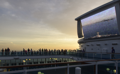
Today was the big day: crossing through the Panama Canal!  An unintelligible announcement in the hall woke us up and we were out on deck (with hundreds of other people!) to watch the sun rise and the ship slowly approach land.  The huge on-deck screen showed the ship’s web-cam from the bow.

dsc_9587

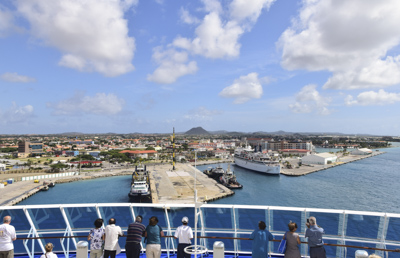
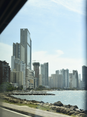
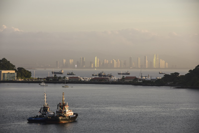
According to the “Princess Patter,” the ship’s daily newsletter, the Pilot and Canal Inspectors came aboard at 0542.  Overnight, the seas around us had filled with countless drifting ships waiting their turns to enter the canal.  As we slowly approached land, the most surprising sight was the modern sky-scraper-filled city of Panama which loomed to starboard out of the morning haze.

dsc_9593

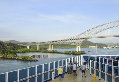
The Island Princess slowly approached our first landmark, Puente de las Americas – the Bridge of the Americas, which spans the Pacific entrance to the Panama Canal at Balbo.  It was built in 1962 and until 2004 had been the only stationary bridge connecting North and South America.  The bridge was part of the Pan-American Highway which runs from northern Alaska to Chile and Argentina.

dsc_9622

dsc_9624

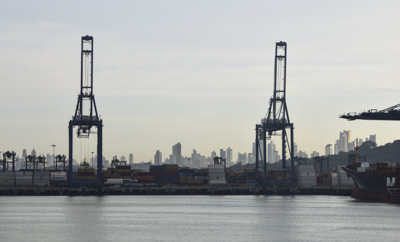
A huge commercial port occupied the shoreline as we crawled toward the canal.

dsc_9631

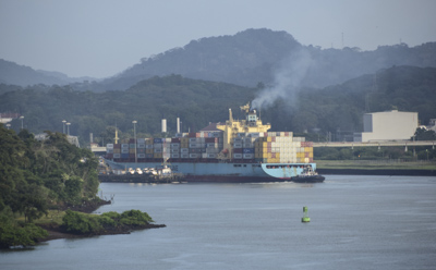
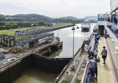
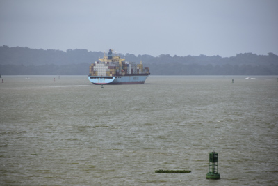
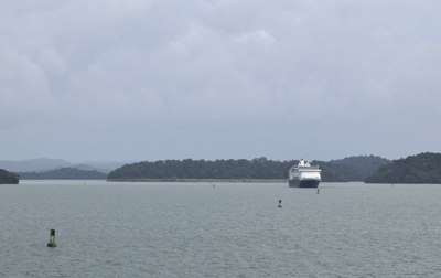
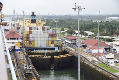
Our of the first view of the entrance to the canal was a large container ship, the Land-Sea Lightening, moving slowly into the first lock: Miraflores.

dsc_9644

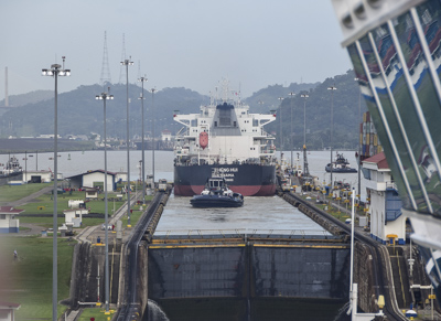
It’s incredible how all these huge ships can get so close to each other!  The Island Princess inched her way into the first chamber of Miraflores lock right behind the commercial ship, Zheng Hui, and waited.

dsc_9661

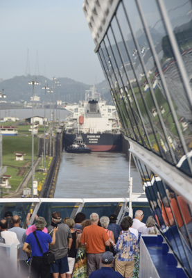
There are two chambers at Miraflores Locks and each is 110 feet wide and 1050 feet long.  The gates closed behind the commercial vessel and very slowly the ship rose higher.

dsc_9665

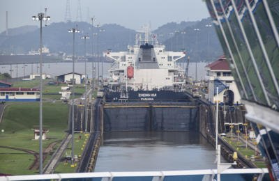
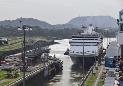
Finally, the gates in front of the Zheng Hui opened and she moved out of the chamber followed by one of the tugboats which had also been in the chamber.

dsc_9676

Meanwhile, the Island Princess was being raised 54 feet in the two chambers of the lock to elevate her from the level of the Pacific Ocean to the higher Miraflores Lake.  The movement on the ship was almost imperceptible and the only way we knew we were being lifted was by looking at the stationary light poles and other structures on land.

dsc_9707

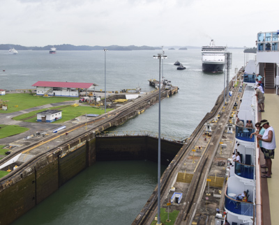
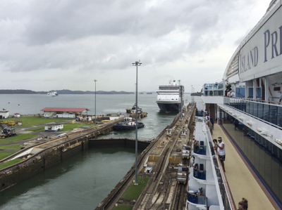
Meanwhile, another cruise ship, the Holland American Veendam, was behind us and gradually entered the other lock on our starboard side.  Although all the ships were moving very slowly, there was a lot happening.  We had fun moving around the ship and checking on the progress of all the ships entering and exiting the locks around us as our behemoth went up and down.  

dsc_9719

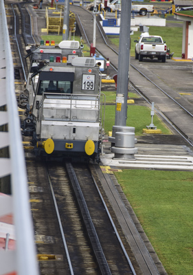
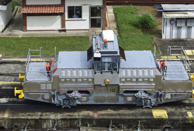
Ships move through the canal under their own power.  Electric locomotive “Mule” engines which run on tracks on land, on each side of the ship, control lateral position inside the locks.  

dsc_9760

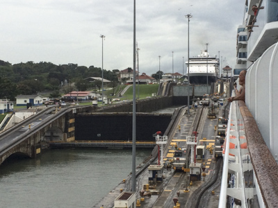
We easily passed through the Esclusas de Pedro Miguel which has a single chamber that raises ships an additional 31 feet.

dsc_9758

dsc_9752

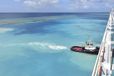
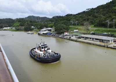
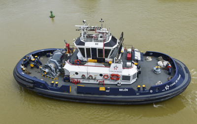
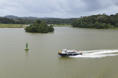
Well equipped tugboats surrounded our ship between locks: two on each side: fore and aft.  They seemed to direct the Island Princess along the buoys and keep our ship from getting too close to shore.

dsc_9781

dsc_9784

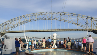
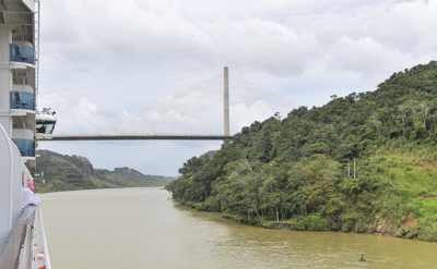
After the single stage Pedro Miguel Locks, we passed under the Centennial Bridge which marks the entrance to the Gaillard or Culebra Cut at the Continental Divide of the Americas.  The bridge, completed in 2004, is the current route of the Pan-American Highway. 

dsc_9792

Culebra means ‘snake’ in Spanish and this winding section of the canal was the most difficult civil work during construction from 1903 to 1914.  The United States completed the work using a ‘lock and dam’ concept and by solving mosquito-borne diseases in the region.

dsc_9803

The United States spent $639 million dollars to build the canal.  28,000 people died out of 80,000 workers during construction due to yellow fever and malaria.

dsc_9813

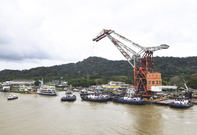
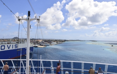
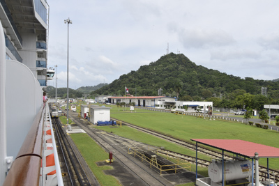
After about an hour, we passed Gamboa which is a small town used to house employees of the Panama Canal and their families.  The photo above shows a repair facility for tugboats and other boats in the fleet.  

dsc_9823

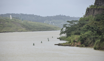
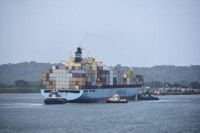
Then the waters opened up to the busy Lago Gatun.  The lake is 85 feet above sea level and was artificially created in 1913 by damming the Chagres River.  We followed the container ship, the Sea-Land Lightening, across the lake:

dsc_9826

The Veendam followed us from buoy to buoy across Lago Gatun:

dsc_9829

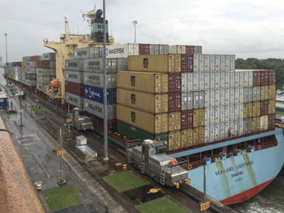
We caught up to the Sea-Land Lightening as she approached Gatun Locks which mark the end of the canal.  The tugboats hovered around the container ship.

dsc_9843

The Island Princess approached Gatun Locks on the port side, next to Land-Sea Lightening:

dsc_9849

img_0494

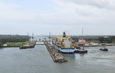
Gatun Lake is 85 feet above sea level.  The double gates closed behind Land-Sea Lightening as she was lowered to Atlantic Ocean level.  

dsc_9902

Right behind us was the Veendam entering the locks on the starboard side while our ship was descending.  There is a marked difference in water level in the three photos below:

dsc_9896

img_0491

img_0497

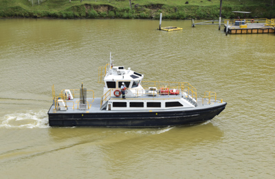
A pilot boat pulled up along side and I watched as 29 (I counted!) people disembarked from our ship and boarded the boat.  I learned later these were the “inspectors” from the canal authority who stayed on board the cruise ship for the day, eating and relaxing as the ship drives through the canal.  Sounds like a good ‘retirement job’ to me!

dsc_9785

The Island Princess passed under the Bridge of the Americas this morning at 6:00am and we reached the end of the Panama Canal and departed Gatun Locks at 3:15pm.  It took us nine hours and fifteen minutes to travel across the 48 miles which is the Panama Canal.  Amazing!

img_0514

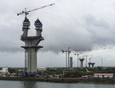
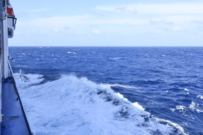
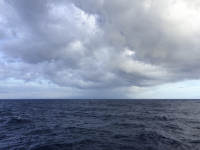
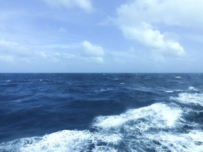
The photo above shows supports for a new bridge which is being built over the canal at the Atlantic entrance.  If I ever return, it will probably be completed.  It rained lightly as the ship departed Panama and head into open waters.  I’d like to say the Island Princess “gunned it” and “let loose” on the Atlantic side after nine hours of crawling along, but at 19 knots an hour, she wasn’t exactly charging ahead.  But it felt like it…..

Another Day at Sea

December 14th, 2016

Wednesday – December 14, 2016

The ship’s clocks were advanced another hour this morning as we traveled southeast.  There was a gentle breeze and the sky was mostly cloudy with passing showers – 78 degrees.

dsc_9542

Today was rest and relaxation after a couple days of excursions ashore.  We enjoyed a leisurely breakfast, then we saw another presentation of Hooray for Hollywood in the theater.  This time it was “Classic Comedies.”  Roy Short does a good job of collecting and showing clips from old movies which we remember from years past.

img_0454

It’s amazing that on a ship filled with 2,000 people we could find quiet corners.  I don’t know where the crowds were, but there seemed to be few people out and about. We relaxed in comfortable lounge chairs on the deck and listened to recorded books.

img_0455

One excellent feature of this ship is that it has about eight laundry rooms on multiple floors.  This is great because travelers don’t have to pack as much clothes.  I always travel everywhere with one “carry-on” size suitcase regardless of how long I’m traveling.  This trip was no exception, although it was a challenge with ‘formal nights.’  The disadvantage to packing light is I have to “do laundry” as I go, so today was a laundry day for me.

dsc_9552

In the afternoon we saw a re-run of David McCullough’s excellent 1987 Nova program about the Panama Canal.  While it might be a bit dated, the information and historical photos and films were very instructive.  The film provided an introduction to our crossing tomorrow.  

dsc_9564

We saw a growing number of commercial ships on the horizon as the day continued. So we knew we were approaching the Panama Canal.  Incredible!  Very exciting!!

Puntarenas, Costa Rica

December 13th, 2016

Tuesday, December 13, 2016    Mostly cloudy, humid  83 degrees 

Another pre-dawn arrival and the Island Princess was tied to a long cement pier when I awoke about eight o’clock.

dsc_9311

The town of Puntarenas, or “sand point” in Spanish, is actually a protected harbor and narrow peninsula of sand jutting out into the Gulf of Nicoya, near the Pacific Ocean.  About a hundred thousand people live in the immediate area and Puntarenas is the closest coastal town to the capital city of San Jose, Costa Rica. 

dsc_9356

Although Puntarenas was discovered in 1522, it was not developed until 1840 when coffee production grew.  We walked off the ship and down the long pier to see the town.  Stalls were arranged along the brown-sand beach with vendors selling Costa Rican souvenirs.  

dsc_9344

dsc_9332

We took pictures and walked to the end of the public area. Daytime temperatures range from 86 to 95 degrees with high tropical humidity.  We rested in a plaza which was decorated with cannons and we happily discovered free wifi.  I quickly sent emails home and then we returned to the ship to prepare for our group excursion from Puntarenas to Caldera.

img_0442

Our guide, “Yonathan,” was a young Costa Rican man sporting long dreadlocks.  We boarded a bus for an hour-long ride to the jungle crocodile safari boat along the Rio Grande de Tarcoles or Tarcoles River.  Although it is “the most contaminated river in Costa Rica,” the Tarcoles was a habitat for American crocodiles, large iguanas, and abundant waterfowl and wading birds.  

img_0450

As Jeff and I boarded the open boat in the sweltering heat, the African Queen came to mind and I felt like Hepburn and Bogart embarking on an adventure.  The scenery was the same as in the movie!

dsc_9420

Yonathan handed out a birding guide as we settled into our seats and the vessel slowly glided through murky waters. The skipper, Jose, was good at finding wildlife along the shore and pulled the boat as close to shore as he could, toward a variety of birds, crocodiles, and lizards.

dsc_9441

dsc_9461

dsc_9469

After we returned to shore without feeding ten-foot long crocodiles, we cooled off in the air-conditioned bus on our way to a restored historic train.  Coffee production, which began in Costa Rica in 1779, played a key role in the history and economy of the country.  The provence of Puntarenas continues to be one of the largest coffee growing regions of Costa Rica.

dsc_9536

The coffee plantation system grew after the government offered farmers plots of land to grow and harvest the plants.  In 1845 oxcarts and horses were used to transport coffee beans from the interior to the port of Puntarenas.  

dsc_9485

As coffee production increased, the first rails were laid in 1854.  At first, mules pulled carts along the narrow gauge railroad called “el burrocarril.”  The rail system was not successful because they were unable to compete with the oxcart drivers who charged lower prices and traveled from coffee farms directly to the port.  It was not until 1890, when a railroad line was completed which could carry coffee from the interior to Puerto Caldera in Puntarenas province to be shipped oversea.    

dsc_9511

It was a fun to ride through the countryside from Tarcoles to Caldera following the trail of the original coffee bean transport lines.  We passed modest houses and large farms with Del Monte signs.  The refurbished coach was decorated with streamers in the colors of the Costa Rican flag: red, white, and blue.  

dsc_9538

It was only a twenty minute bus ride back to the ship from Caldera.  We dressed up for dinner in the Bordeaux Dining Room and enjoyed a celebratory feast.  Jeff had roast beef and Yorkshire pudding and I had baked salmon with grilled veggies.  It had been an interesting and fun day!

San Juan del Sur, Nicaragua

December 12th, 2016

Monday, December 12, 2016     Overcast with Showers and a ‘Fresh Breeze’ – 84 degrees

I was awakened to the sound of machines lowering the tenders into the water of the bay. We had arrived in San Juan del Sur, Nicaragua some time during the early hours and the ship dropped anchors off shore.  

dsc_9092

I opened the curtains expecting to see a bright sunny day but everything was overcast and gray.  I stepped out onto the balcony to watch as a tender moved toward the green shore.  It was raining lightly.

dsc_9078

We waited until eleven to take one of the tenders ashore to walk around the horseshoe shaped harbor.  Vendors lined the main street selling crafts to the tourists.  There were several local youths dressed in bright red costumes dancing to lively Nicaraguan music.

dsc_9114

One of the hotels on the street is famous because Mark Twain stayed there when he visited Nicaragua.  It was newly painted in bright whitewash. The bright pink building pictured below is La Cantina, a Mexican restaurant.

dsc_9118

San Juan del Sur has a population of about 15,600 people most of whom make a living by fishing or tourism.  A large statue of the Mirador del Cristo de la Misericordia stands on a hill above the town.  It is one of the largest statues of Jesus in the world and is a tourist attraction.  The woman in the photo below was asking tourists for donations “to feed her black-face monkeys.”

dsc_9130

The small building below is the oldest house in San Juan del Sur and was built in 1912 using “rustic” building materials and old methods of construction  popular a hundred years ago.

dsc_9149

We walked back to the terminal to meet a local guide named, Bismar, and we board a brightly colored bus to visit the city of Rivas, Nicaragua.  On the way, Besmar told us about the history of Nicaragua, the development of San Juan del Sur during the 1849 “Gold Rush, the recent political climate, and the current plan to build a canal across Nicaragua by a Chinese company.  

dsc_9188

Rivas is located between Lake Nicaragua and the Pacific Ocean.  According to a guide, the city is full of Spanish colonial architecture.  The bus stopped at the cathedral (sorry I don’t have better photos of the exterior because it was drizzling) and we filed inside.  

dsc_9166

The original church was built in 1607 but has been renovated several times through the centuries. The most striking features of the building were the beautiful wooden ceiling and hand painted dome.

dsc_9183

We drove along the shore of Lake Nicaragua, the largest lake in Central America.  There are two islands just off shore which contain active volcanoes, unfortunately visibility was limited.  We passed miles of wind turbines which successfully provide electricity to the region because of strong winds over the lake.

dsc_9204

We stopped at Amayo Farm which is supposed to be owned by the niece of Violeta Chamorro, the former president of Nicaragua.  It was a very beautiful tropical property which sloped gently down to the lake.  There were chickens and livestock outside a rambling lovely house. 

dsc_9217

Our group sat on a large veranda and were treated to soft drinks and fresh fruit.  We were entertained by musicians and local dancers in bright costumes.  

dsc_9236

dsc_9241

We walked down to the volcanic sand beach but it was drizzling and visibility was too poor to see the tops of the volcanoes.  It was a twenty minute ride back to the ship and we were lucky that heavy rain held off until the end of our tour.  It was fun to see the towns of Nicaragua and drive through the tropical countryside.  

Back on the Island Princess we were treated to a jazz performance by Pavlova & Yakeo playing piano and saxophone. Later we watched Lorenzo Clark’s act of “Amazing Comedy & Funny Magic” in the theater.  It had been a busy day.